
Data Visualization
Choose from multiple imageries and other base maps. Tailor to your data and reporting needs.
5-Star Support
TreePlotter™ tree inventory software has a proven track record of 5-Star customer support.
Customizable
Add on modules to get additional functionality.
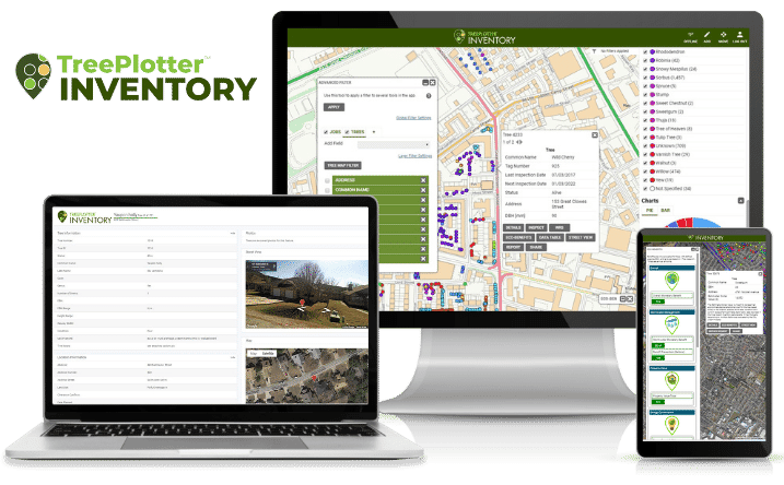
Manage from Anywhere
From risk assessment to tree appraisals to paperless work orders, any data can be updated live in the field, online or offline.
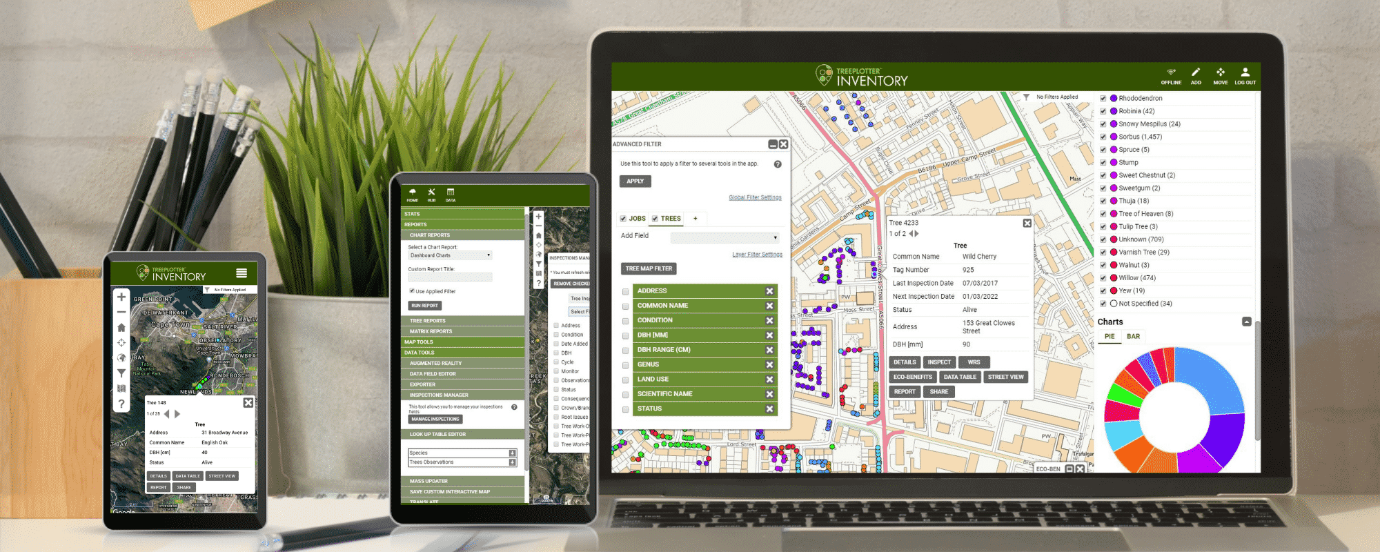
Interactive Maps
Tell a more powerful story. Color-code trees by any attribute, save preset data filters, and share interactive maps via URL.
Smooth Integration
Integrates through web APIs with other cloud-based enterprise systems such as Esri, asset management, and customer service request systems.
Better Your Technology. Better Your Forest.
All the tools to get the job done
Protected account info/log in
Add/edit map points
Data management
Export data
Filter data/save templates
Geocoding services
Google street view
Interactive map legend
Mass update
Save interactive map url
Exceptional support
Canned and custom reports
TreePlotter™ tree inventory software has a proven track record of 5-Star customer support.
Community Engagement Map
This innovative core feature will educate and engage the public and your clients
The Community Engagement Map (CEM) is a way to connect the public with the trees in your TreePlotter™ INVENTORY application. Through the CEM, you can share your organization’s trees or specific clients trees with public viewers in real-time. The trees are displayed on a map where viewers can see their location, the Eco Benefits, and other customizable information.
EDUCATE
CONNECT
ENGAGE
INVENTORY – Public Entity Pricing
Governments, nonprofits, and campuses of all sizes use TreePlotter INVENTORY for comprehensive tree inventory and tree management. Design your optimal software solution with four product levels and a suite of innovative Add-On functionalities.
All prices listed are US. Please contact us for international pricing.
BASE

Most Used By
Golf Courses
Small University Campus
Small NPO
Airport
1 Year Starts At
$2,000 up to 10K Trees
Talk With Sales for International Pricing
Includes ONBOARDING and SOFTWARE SUPPORT
Complete

Most Used By
Small-Mid Size Municipality
County
1 Year Starts At
$7,000 25-100K Trees
Talk With Sales for International Pricing
Includes ONBOARDING and SOFTWARE SUPPORT
Advanced

Most Used By
Mid-Large Municipality
Mid-Large NPO
1 Year Starts At
$11,000 25-100k Trees
Talk With Sales for International Pricing
Includes ONBOARDING and SOFTWARE SUPPORT
Enterprise

Most Used By
Large Municipality
Large Corporate Campus
State Agency
Housing Authority
Parks District
Custom
INVENTORY – Private Entity Pricing
From one-man consultants to multi-crew ops, TreePlotter INVENTORY helps companies deliver exceptional tree care. Find the right fit for your company with three product levels and a suite of innovative Add-On functionalities.
All prices listed are US. Please contact us for international pricing.
BASE
Most Used By
1-2 users
Small tree care company
1 Year Starts At
$2,000
Talk With Sales for International Pricing
Includes ONBOARDING and SOFTWARE SUPPORT
Complete
Most Used By
5+ users
Medium-large tree care company
1 Year Starts At
$4,500
Talk With Sales for International Pricing
Includes ONBOARDING and SOFTWARE SUPPORT
Enterprise
Most Used By
10+ users
Large tree care company
Multi-unit housing authority
Custom
Featured Add-On Modules
Add-on modules and customizations to fit your tree inventory software needs
Collect data efficiently without an internet connection
Offline Collector
Electronic level 2 ISA advanced risk assessment form
Advanced Risk Assessment
Quantify monetary and ecological tree benefits
Eco Benefits
Public sector focus – mapping, database, and reporting system
Work Order Management
Collect data efficiently without an internet connection
Offline Collector
Electronic level 2 ISA advanced risk assessment form
Advanced Risk Assessment
Quantify monetary and ecological tree benefits
Eco Benefits
Public sector focus – mapping, database, and reporting system
Work Order Management
Support Resources
Tree inventory software support is always at your fingertips
Webinar
Demo App
FAQ's
A Few of our Satisfied Clients
PlanIT Geo™ has a proven track record of industry-leading support
“The fact that TreePlotter™ can be customized to the needs of my organization makes it fit our workflow really nicely. Probably the best part about (it) is the customer service and the fast response I get from TreePlotter™ developers.”
“The customization and features offered are far superior to the previous tree inventory software we were using.”
“The accuracy of the GPS coordinates is terrific, this helps not only for street trees but for locating trees growing in parks and greenways. Data collection can be done using any device that has an internet connection, eliminating the need for expensive equipment.”
Let’s discuss your next community forestry project today.
About PlanIT Geo™
At PlanIT Geo, you’ll find a team driven by trees and technology. We are innovators and your partner in community forestry.
We are passionate about the work we do and derive purpose from helping others map and understand the value of nature-based solutions for a greener future.
TreePlotter Support
Current clients can visit our support site to get updates, feature releases, and answers to many commonly asked questions.
TreePlotter Support Website
Contact
PO Box 1334, Wheat Ridge, CO 80034
Sales & Support: 833.873.3627
U.K. Contact
U.K. Sales: 07906625472
U.K. Support: 03330 509905
TreePlotter UK Website
Follow Us
Join Our Community