
Customizations and Add-On Modules
Customize your TreePlotter™ AppsPublic sector focus – mapping, database, and reporting system
Work Order Management
Quantify monetary and ecological tree benefits
Eco Benefits
Collect data efficiently without an internet connection
Offline Collector
Electronic level 2 ISA advanced risk assessment form
Advanced Risk Assessment
Add SHP or CAD files to view as a layer on the map alongside all data
Reference Layer Importer
Efficiently calculate and report appraised tree value
Tree Appraisal
A unique landing page to inform and engage your audience
Configurable Landing Page
Our web-based platform allows integration with an existing technology stack
API and WFS Integrations
Quantified Tree Risk Assessment Calculator
Quantified Tree Risk Assessment
Protect trees during construction projects using CAD and GIS
Development Survey – UK
Simplified login process using your own authentication provider
Single Sign On
Contact us to activate free customizations:
Tree Protection Zone, Augmented Reality, Notifications, Feature History, and Inspections
Add-On Modules start at $1000 USD

Work Order Management
Public sector focus
What it is
- A mapping, database, and reporting system for tree bid estimates, work orders, service requests, and invoices
- Designed with the public sector in mind
What it does
- Provides automated, customizable workflows, forms, reports, and emails
- Tracks costs and changes to job and work status
- Archives completed work to build history and record for both the jobs and individual tree levels
- Ensures integrity and quality of tree inventory and work order data
- Allows you to visualize, search, sort, edit, and share tree work with clients and stakeholders
Why you need it
- Save time, increase efficiency, and professionalism
- Communicate efficiently and effectively with internal staff, contractors, and clients
- Unlimited users able to add, edit, and update status in real-time
- Work seamlessly with park assets and amenities data
Existing clients please VISIT OUR SUPPORT PAGE for additional resources.

Single Sign On
SIMPLIFIED LOGIN PROCESS USING YOUR OWN AUTHENTICATION PROVIDER
What it is
- Single Sign On (SSO) is a technology that separates the roles of SaaS service provider (PlanIT Geo) and identity authentication provider (e.g., Microsoft Azure)
- It allows for an internal IT department to retain control of their overall user list and their user’s passwords
What it does
- The SSO functionality can be used with TreePlotter INVENTORY or CANOPY
- When a user tries to log in they will be directed to a new sign in page where they can sign in with their corporate email and password
- If the user is not connected to a corporate email they can use their own email and password to login
Why you need it
- The Single Sign On functionality is valuable for any customer that prefers to retain full control over the identity and authentication aspects of the login process
Existing clients please VISIT OUR SUPPORT PAGE for additional resources.

Eco Benefits
Quantify monetary and ecological tree benefits
What it is
- Provides monetary and ecological tree benefits, and calculations based on i-Tree research
What it does
- Benefits analysis is responsive to filters and queries, providing values ranging from whole communities to a single tree
- Produce automated analysis and i-Tree calculations with no additional input needed
Why you need it
- Clients, government leaders, and funders are able to quantify the urban forest at a click of a button.
- Visual, open-source communication tool for engagement and solidifies investing in urban forest management.
- Added value to your bidding and communication strategies
Existing clients please VISIT OUR SUPPORT PAGE for additional resources.

Offline Collector
Collect data efficiently without internet connection
What it is
- Continuously collect data efficiently without a data plan or with limited to no service in the field.
What it does
- You designate the area(s) in the map where you want to collect data while online, then go into the field offline to work in this area. Existing data will also appear in order to edit.
- Connect to the internet and Offline Collector will “sync” all new and edited data points to your online map with the click of a button
Why you need it
- Un-interrupted and fast data collection
- Avoid the cost of a data plan
- Conduct inventory in areas with little or not service with no interruptions to your work production
Existing clients please VISIT OUR SUPPORT PAGE for additional resources.

Tree Appraisal
Efficiently calculate and report appraised tree value
What it is
- Efficiently calculate and report tree appraisal value.
- Based on the CTLA Guide for Plant Appraisal (10th edition) Trunk Formula Method.
What it does
- Easily enter ratings and regional costs, then appraisal value is calculated for you.
- Create a single tree appraisal report or a multiple tree report for your appraisal project.
Why you need it
- Deliver comprehensive, accurate, and easy to understand information.
- Save time by entering, searching, and manipulating appraisal and tree data in one place for all your projects
- Work seamlessly with park assets and amenities data
Existing clients please VISIT OUR SUPPORT PAGE for additional resources.

Advanced Risk Assessment
Electronic level 2 ISA advanced risk assessment form
What it is
- An expanded tree risk assessment tool based on the ISA Tree Risk Assessment Qualifications
- Created in collaboration with an ISA TRAQ development contributor and instructor
What it does
- Follows the 2 page ISA TRAQ form report and risk matrices, and populates risk level based on user input
- Easily create a single tree form report with one click or multiple tree summary tables for detailed reports
- Color code all trees in map by risk level
Why you need it
- Creates a standard process and methodology for your tree risk assessments
- Deliver professional and accurate reports that empower tree managers and owners to make informed decisions
Existing clients please VISIT OUR SUPPORT PAGE for additional resources.
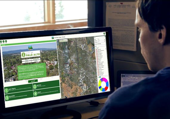
Configurable Landing Page
A unique landing page to inform and engage your audience
What it is
- A creative and engaging landing page for your application
What it does
- This configurable landing page add-on module is a visually engaging page that allows you to add images, videos, training, contact information, crowd sourcing, on-brand color selections, and much more
Why you need it
- Effective marketing and outreach tool to engage your audience from the second they visit your Tree Plotter application
- Lead your clients or constituents to connect, and direct their attention to your specified call to action
Existing clients please VISIT OUR SUPPORT PAGE for additional resources.
Development Survey
Protect trees during construction projects using CAD and GIS
What it is
- UK specific add-on module to TreePlotter™ INVENTORY for consultants to meet and exceed the requirements set out in BS 5837 (Trees in relation to design, demolition, and construction)
What it does
- Accurately map tree canopies, root protection areas, import/export CAD files, and more while in the field
- Imported CAD files are visible as reference layers giving you the ability to plot any tree, hedgerow, group of trees, or woodland that could be affected during the design, demolition, or construction phase of any development
Why you need it
- Communication and clarity are handled quickly and easily with the ability to import your data directly into reports
- Eliminate the hassle of back and forth communication to create accurate and engaging reports
Existing clients please VISIT OUR SUPPORT PAGE for additional resources.

API and WFS Integrations
Integrate with your existing technology
What it is
- The TreePlotter™ INVENTORY API allows developers to interact programmatically with map features and other data in an INVENTORY app
What it does
- It creates an integration with your existing system, such as a city asset management system, or a complex ESRI environment
- Display map features from INVENTORY in your own web app, mobile app, or desktop app
- Load data into ArcMap, QGIS, or another desktop application for analysis
Why you need it
- Governmental parks and tree management professionals need to incorporate their data into already existing systems due to implementation of new management systems
- TreePlotter’s API allows for these interactions to seamlessly transfer data, without any manual uploads or downtime
Existing clients please VISIT OUR SUPPORT PAGE for additional resources.

Quantified Tree Risk Assessment (QTRA)
Enter and record the input values to calculate and record the Risk of Harm
What it is
- Quantitative Tree Risk Assessment (QTRA) is one of several methods for determining the potential risk of failure of a tree or tree limb. It was developed in the UK and has been widely adopted by tree care specialists across the globe.
- The QTRA Method provides a framework for the assessment of the three primary components of tree-failure risk. Target, Size and Probability of Failure.
- The QTRA API allows users to perform an assessment on a tree where they enter and record the input values to calculate and record the Risk of Harm which is subsequently used to determine further potential action.
What it does
- Ranges of value for Target, Size, and Probability of Failure are entered into a QTRA calculator which generates the QTRA value
- Easily create a single tree form report, or multiple tree summary tables for detailed reports
- Color code all trees in map by risk level
QTRA Calculator Access and Use
- Log in to your TreePlotter Inventory account
- Once you are in the QTRA calculator fill out the form according to your field survey
Existing clients please VISIT OUR SUPPORT PAGE for additional resources.
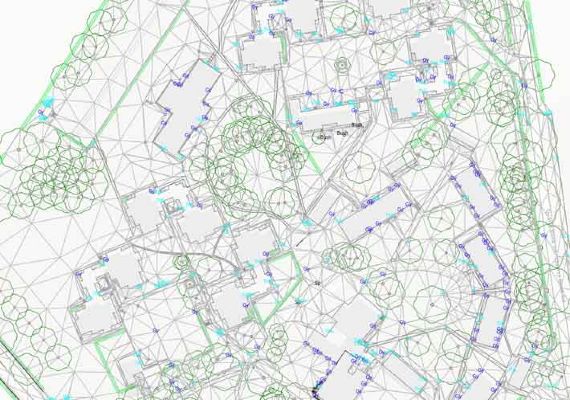
Reference Layer Importer
Add SHP or CAD files to view as a layer on your map
What it is
- It allows users to upload a Shapefile or CAD file to their TreePlotter INVENTORY or PARKS applications
- View that data alongside their other tree and asset layers
What it does
- Allows you to toggle all available reference layers on and off, add trees and assets in relation to the layer you are referencing, and interact with the layers seamlessly
- CAD files will automatically pull colors and labels associated with features
Why you need it
- Communication and clarity are handled quickly and easily with the ability to import your data directly
- Eliminate the hassle of back and forth communication to create accurate and engaging reports
Existing clients please VISIT OUR SUPPORT PAGE for additional resources.
Let’s discuss your next community forestry project today.
About PlanIT Geo™
At PlanIT Geo, you’ll find a team driven by trees and technology. We are innovators and your partner in community forestry.
We are passionate about the work we do and derive purpose from helping others map and understand the value of nature-based solutions for a greener future.
TreePlotter Support
Current clients can visit our support site to get updates, feature releases, and answers to many commonly asked questions.
TreePlotter Support Website
Contact
PO Box 1334, Wheat Ridge, CO 80034
Sales & Support: 833.873.3627
U.K. Contact
U.K. Sales: 07906625472
U.K. Support: 03330 509905
TreePlotter UK Website
Follow Us
Join Our Community